Distance Calculator
You can use this distance calculator to find out the distance between two or more points anywhere on the earth. In other words, the distance between A and B. Click once on the map to place the first marker and then click again to position the second marker. The distance between the points will then be displayed. You can also build up a series of locations to find a total distance.
Use search result as a distance marker?


Paste in the list of coordinates to add to your route in the text box below:
About
An important feature of this distance calculator tool is that it is "as the crow flies", so traveling in real life will normally involve larger distances, but this may also help those who need to measure direct distances.
Want to save your route? Try the Advanced Google Maps Distance Calculator
How To Use
- Zoom and drag the map to find the location of marker 1
- Click to place marker 1.
- Zoom and drag the map to find the location of marker 2.
- Click to place marker 2.
- The distance will be calculated then displayed below the map in miles or kilometers. You can change between miles or km at any time
- Add as many points as required and the distance will build up.
- You can also drag and drop markers after they have been put on the map
- To share your route and distance calculation use the option [Generate Link For This Route]. You can then copy the link generated and send this via Twitter or Facebook.
Options
- Click [Clear Last] to undo the last marker placed
- Click [Zoom To Fit] to zoom the map around all markers
- Click [Clear Map] to erase all markers and start again
- Use the Quick Find text box to quickly relocate the map
- You can choose between miles and kilometers (km) for the Total Distance readout
- Click [Show Elevation] to get a chart showing the elevation of your route
How it Works
Clearly you, the user inputs two 'points' that are used to calculate the distance. Calculating the "As the Crow Flies" distance is a matter of using Great Circle formula. Then the main problem is converting the Google Map unit to miles and kilometers.
The map will also automatically save your route in your temporary internet cookies so that you can return and see the route as you last left it. If you ever need to start from scratch then use the [Clear Map] button.
Disclaimer
All distances are estimations so Daft Logic does not accept any responsibility that may arise when the value reported is incorrect.
Benchmark Tests
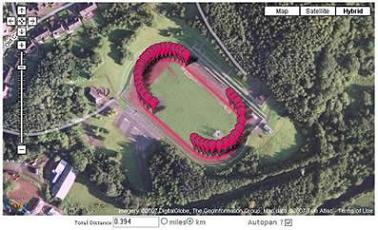
Map showing the Mary Peters Track in South Belfast. The reading shows 0.394km which is clearly a reasonable measurement for an athletics track.
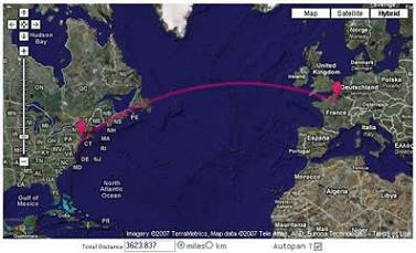
Map showing the estimated distance between New York and Paris. All references that can be found suggest that this is an accurate measurement.
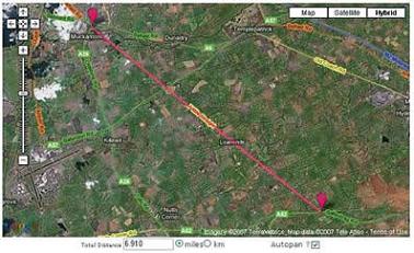
Map showing the Seven Mile Straight in County Antrim, Northern Ireland. This shows a reading of 6.910 miles.
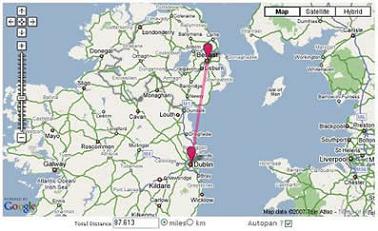
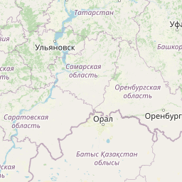
Map showing the distance between Belfast and Dublin. As far as I can see this is an accurate estimate (if there is such a thing). This trip would be approximately 100 miles by road so the proverbial crow would have less distance to travel.
Relevant Links
Further Uses and Ideas
- Remember auto-pan setting between sessions
- Show difference in elevation between markers
- Export a list of all waypoints and show the distance between each
Version History
| Version | Date | Description of Updates |
|---|---|---|
| 7.0 | 22th March 2025 | UI Updates |
| 6.7 | 25th April 2022 | Bug fix: Upload Coordinates |
| 6.1 | 5th February 2021 |
Bug Fix: Clicking on an existing marker to add to the route did not work and also caused the tool to stop functioning Bug Fix: Autopan did not work initially until switched off and on. |
| 6.0 | 1st February 2021 | Implemented Leaflet Maps |
| 5.1 | 2nd August 2010 | Fixed autopan issue when map is resized |
| 5.0 | 31st July 2010 |
Implemented Google Maps Javascript API V3 Google Search bar at bottom left is not yet available. Sorry! Removed show mid-point button Uses new cookie so any previous systems/settings on your machine will be erased! Sorry! Please report any issues or bugs! |
| 4.1 | 21st February 2008 |
Removed Scroll Wheel Zoom in and out Added marker drag and drop functionality Removed Print Option (Ctrl+Print Screen works better) |
| 4.0 | 20th January 2008 |
Added Scroll Wheel Zoom in and out Complete conversion to API v2 Better Zoom to Fit Functionality Added crosshairs cursor |
| 3.2 | 1st October 2007 | Added Quick Find |
| 3.1 | 25th September 2007 | Added print map option |
| 3.0 | 15th June 2007 |
Move to API v2 Great Circle display and distance calculation Option to resize map height |
| 2.0 | 19th January 2006 |
Stop post back between clicks Calculate Mid Point Zoom to fit feature More than one marker as running total |
| 1.0 | 29th December 2005 | The Beginning |
Comments For This Page
mingle, can you explain how it doesn't work?
By Daft Logic on 1st April 2025it dosent work
By mingle on 1st April 2025There used to be an excellent profile view (side on view) that showed the elevation points between the two or more location points plotted. You could see the rise and fall of the terrain between the points. I recall Google's fee for DaftLogic being able to continue providing this screwed this up, but that was a long time ago. Has anything changed since as, surprisingly, I cannot find anyone else providing this feature online?
On 5th January 2025Is there any way to import a route from this Distance Calculator to the newer Advanced Google Maps Distance Calculator?
By J Huang on 26th July 2024I noticed the same thing as below and some of the Russian roads have propaganda inserted where the street name would go.
On 17th June 2024Just curious. I've been using Daft Logic weekly, if not more often, for several years. Yesterday, it suddenly overlay roads from elsewhere in the world, probably somewhere in Russia, based on the road names (POCCNR, e.g.). This morning, it further overlaid road names that appear to be British (Rudgate, York). These were visible, criss-crossing the local roads in the Johnson Creek, Wisconsin, vicinity when one zoomed in part-way. Very strange. ???
On 16th June 2024Very nice, great tool for multiple tasks. Thanks.
By Abbas Baloch on 1st May 2024I thing is great to know how many time we need to get the place we work
By Kleber Caraguay on 4th April 2024March 5 2024
Daft Logic maps went from being my "all time favourite map tool" to the "most mediocre of the mediocre"
This is where we part company. Bye
I love this app and please keep it going. It makes plotting out training running distances on old train paths a breeze! much love.
By scrappy runner on 27th January 2024I've been using this webpage since I found it last 5 yrs ago and it helps me get an accurate distance vs the fare I am paying since most of the public utility vehicle drivers are charging us people excessively. I hope this page wont die
By Mich on 19th November 2023cannot get location !!!!
On 4th October 2023Every time I try to do the distance calculator and switch from OSM to satellite all i get is a message in the center that says loading and it doesn't make any difference what browser I use, got any ideas whats wrong?
By Tommy on 1st June 2023This is awesome!! Maybe add an option to change the color of the markers?
On 20th October 2022Nice job! Yes, it is now working for loops, but it has a strange way to calculate distances. As I see in the map, it is as if it calculates distances in straight patterns, like flying between points. No road trips? :)
At least is it using Haversine calculus or Geodesic ones for these distances?
Emiliano, it should be working now.
By Daft Logic on 25th April 2022Nice software but does not like to do round trips. Try:
41.27527778 28.75194444
39.116667 27.183333
39.11902613 27.16561247
39.13205278 27.18386585
37.94111111 27.34194444
37.70944 28.72706
37.9204972 29.121
37.92671 29.12905
37.912 29.11948
36.549333 29.115
36.496799 29.127331
36.26209 29.98686
36.4315 30.4559
36.40899351 30.47135766
36.89767 30.71875
36.94254106 31.17234748
38.37497414 35.08924216
38.6456 34.8442
38.65612716 34.84267815
38.64167277 34.83234002
38.37497414 35.08924216
38.66082513 34.81968777
38.66509326 34.81931268
38.66927161 34.86348966
38.64019992 34.84536543
38.62139561 34.80591193
38.63013579 34.80359077
38.65289095 34.86246957
38.37497414 35.08924216
38.99096557 33.32979705
39.94119651 32.86584735
41.25425167 32.71193256
41.27527778 28.75194444
Or any A->B->C->A
What has happened to this app?
The "remove last marker" button and "clear map" etc have disappeared!!??
PLEASE! Fix these issues bc I enjoy using usually. The clarity of the satellite photos is lacking as well, making me wonder how old the images are. No need to slog thru what you *hope* is the right location, when clear sat views do exist!
8,317 miles seem like an erroneous reading. Any test we do is <4000 miles
By Daft Logic on 24th February 2022This shows to me that the distance between Madrid Spain and Asheville North Carolina is 8, 317miles, whereas Google Maps tells me that as the crow flies it is only 4,154 miles
On 23rd February 202220 out of 2208 comments shown.
Add Your Comment
There's no need to create an account or provide unnecessary details. Just your comment.